NYU Researchers Propose A Novel Remote Sensing Object Detection Dataset For Deep Learning Assisted SaR

Any machine learning algorithm’s core component is data. The first need for successful outcomes is a decent dataset. At the moment, in-domain datasets are essential for applying machine learning models to practical issues. One such issue is finding missing people in distant areas, where access might be challenging, and speed is crucial. Most of the photos in databases for visual search and rescue (SaR) thus far have been captured by UAVs or small aircraft. Due to the wider variety of perspectives and relatively high target sizes, this data cannot be directly transferred to a satellite imaging environment, where there are presently no SaR datasets. A solid supplement for aerial searches may soon be made possible by contemporary constellations of high-resolution satellites that can photograph practically every location on Earth in a matter of hours, especially when combined with recent developments in deep learning.
To illustrate the idea of deep learning aided SaR, a unique object detection dataset gathered in a live search environment is required. The information was produced as part of the investigation into the disappearance of a paraglider pilot who got away in a remote and hilly region of the western United States. Using axis-aligned bounding boxes, more than 500 participants identified probable targets in high-resolution photos. After a three-week search, the correct target—shown inset in figure 1—was located, and the labels created for possible targets were stored. This dataset of 2552 photos was created by the post-processing of these photographs and annotations.
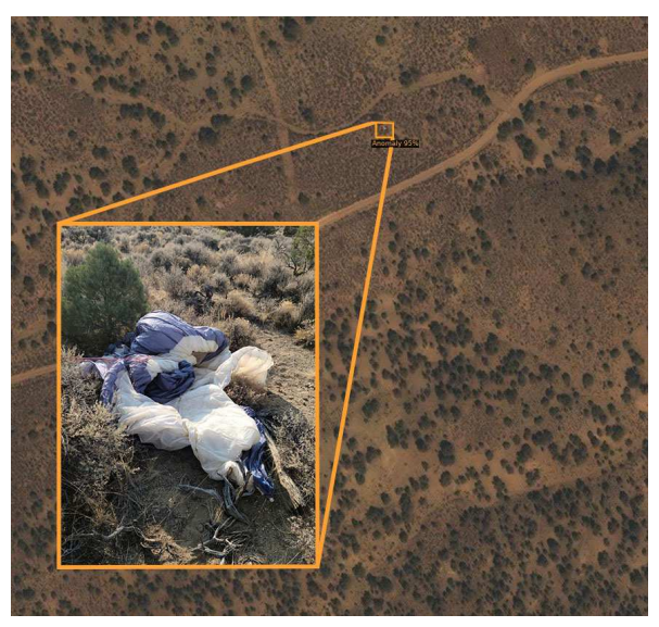
A problematic application for off-the-shelf deep learning techniques is to search and rescue using satellite images. Metrics are commonly used to assess a model’s effectiveness on datasets Fig. 1. As it was discovered, the paraglider wing is as shown inset the prototype system’s detection of the wing. When the underlying truth is reasonably certain and labeling is consistent, methods like MS-COCO are pretty revealing, but they have some problems when labels are noisy.
Systems incorporating human verification into the target acquisition process can often live with less precision. We provide a brand-new measure more appropriate for deep learning-assisted SaR and a simple method for selecting a detection threshold for a given batch of test photos. Using this new measure and our dataset, we will compare various well-known object detection methods. These are the contributions that developers of SarNet made:
- Provide a new dataset for SaR based on satellite images
- A novel and valuable measure for object recognition in a SaR scenario
- A comparative analysis of well-known object detection models trained and tested on this dataset.
The dataset contains 2552 images with a total of 4206 axis-aligned bounding boxes of a single ‘target’ class which will help future studies of SaR based on satellite photography. Apart from this they provided a baseline model trained on this dataset to illustrate the profound learning-aided SaR idea and offered a novel measure that may help apply object detectors to SaR challenges. They believe that satellite-based SaR is a developing area with the potential to save lives and provide closure to the relatives of the lost. This technology can be used to look for lost airplanes, ships, and several other unimaginable targets.
The data is available on GitHub in COCO format along with a pretrained R-CNN model.
This Article is written as a summary article by Marktechpost Staff based on the paper 'SaRNet: A Dataset for Deep Learning Assisted
Search and Rescue with Satellite Imagery'. All Credit For This Research Goes To Researchers on This Project. Checkout the paper, code.

Please Don't Forget To Join Our ML Subreddit
Credit: Source link
Comments are closed.